 Mount Everest, also known in Nepal as Sagarmāthā and in Tibet as Chomolungma, is Earth's highest mountain. It is located in the Mahalangur mountain range in Nepal and Tibet.[8][9] Its peak is 8,848 metres (29,029 ft) above sea level.[1] It is not the furthest summit from the centre of the Earth. That honour goes to Mount Chimborazo, in the Andes.[10] The international border between China (Tibet Autonomous Region) and Nepal runs across Everest's precise summit point. Its massif includes neighbouring peaks Lhotse, 8,516 m (27,940 ft); Nuptse, 7,855 m (25,771 ft) and Changtse, 7,580 m (24,870 ft).
 In 1856, the Great Trigonometrical Survey of India established the first published height of Everest, then known as Peak XV,
at 8,840 m (29,002 ft). The current official height of 8,848 m
(29,029 ft) as recognised by China and Nepal was established by a 1955
Indian survey and subsequently confirmed by a Chinese survey in 1975. In
1865, Everest was given its official English name by the Royal Geographical Society upon a recommendation by Andrew Waugh, the British Surveyor General of India. Waugh named the mountain after his predecessor in the post, Sir George Everest, arguing that there were many local names, against the opinion of Everest.[11]
 Mount Everest attracts many highly experienced mountaineers as well
as capable climbers willing to hire professional guides. There are two
main climbing routes, one approaching the summit from the southeast in
Nepal (known as the standard route) and the other from the north in
Tibet. While not posing substantial technical climbing challenges on the
standard route, Everest presents dangers such as altitude sickness, weather, wind as well as significant objective hazards from avalanches and the Khumbu Icefall.
 The first recorded efforts to reach Everest's summit were made by British mountaineers.
With Nepal not allowing foreigners into the country at the time, the
British made several attempts on the north ridge route from the Tibetan
side. After the first reconnaissance expedition by the British in 1921 reached 7,000 m (22,970 ft) on the North Col, the 1922 expedition
pushed the North ridge route up to 8,320 m (27,300 ft) marking the
first time a human had climbed above 8,000 m (26,247 ft). Tragedy struck
on the descent from the North col when seven porters were killed in an
avalanche. The 1924 expedition resulted in the greatest mystery on Everest to this day: George Mallory and Andrew Irvine
made a final summit attempt on June 8 but never returned, sparking
debate as to whether they were the first to reach the top. They had been
spotted high on the mountain that day but disappeared in the clouds,
never to be seen again, until Mallory's body was found in 1999 at
8,155 m (26,755 ft) on the North face. Tenzing Norgay and Edmund Hillary made the first official ascent of Everest in 1953 using the southeast ridge route. Tenzing had reached 8,595 m (28,199 ft) the previous year as a member of the 1952 Swiss expedition. The Chinese mountaineering team of Wang Fuzhou, Gonpo and Qu Yinhua made the first reported ascent of the peak from the North Ridge on May 25, 1960.[12][13]
| Mount Everest | |
|---|---|
| सगरमाथा (Sagarmāthā) ཇོ་མོ་གླང་མ (Chomolungma) 珠穆朗玛峰 (Zhūmùlǎngmǎ Fēng) |
|

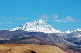
Everest's north face from the Tibetan plateau
|
|
| Highest point | |
| Elevation | 8,848 m (29,029 ft) [1] Ranked 1st |
| Prominence | 8,848 m (29,029 ft) Ranked 1st (Notice special definition for Everest) |
| Listing | Seven Summits Eight-thousander Country high point Ultra |
| Coordinates | 27°59′17″N 86°55′31″ECoordinates: 27°59′17″N 86°55′31″E [2] |
| Geography | |

Mount Everest
|
|
| Location | Solukhumbu District, Sagarmatha Zone, Nepal; Tingri County, Xigazê, Tibet Autonomous Region, China[3] |
| Parent range | Mahalangur Himal, Himalayas |
| Climbing | |
| First ascent | 29 May 1953 Edmund Hillary and Tenzing Norgay (First winter ascent 1980 Leszek Cichy and Krzysztof Wielicki[4][5]) |
| Normal route | southeast ridge (Nepal) |

Aerial photo from the south, behind Nuptse and Lhotse

Mount Everest from space

Tibetan Plateau and surrounding areas above 1600 m with height colour coded.[6][7]

Mount Everest and the snow-capped Himalayas from orbit
In 1856, the Great Trigonometrical Survey of India established the first published height of Everest, then known as Peak XV, at 8,840 m (29,002 ft). The current official height of 8,848 m (29,029 ft) as recognised by China and Nepal was established by a 1955 Indian survey and subsequently confirmed by a Chinese survey in 1975. In 1865, Everest was given its official English name by the Royal Geographical Society upon a recommendation by Andrew Waugh, the British Surveyor General of India. Waugh named the mountain after his predecessor in the post, Sir George Everest, arguing that there were many local names, against the opinion of Everest.[11]
Mount Everest attracts many highly experienced mountaineers as well as capable climbers willing to hire professional guides. There are two main climbing routes, one approaching the summit from the southeast in Nepal (known as the standard route) and the other from the north in Tibet. While not posing substantial technical climbing challenges on the standard route, Everest presents dangers such as altitude sickness, weather, wind as well as significant objective hazards from avalanches and the Khumbu Icefall.
The first recorded efforts to reach Everest's summit were made by British mountaineers. With Nepal not allowing foreigners into the country at the time, the British made several attempts on the north ridge route from the Tibetan side. After the first reconnaissance expedition by the British in 1921 reached 7,000 m (22,970 ft) on the North Col, the 1922 expedition pushed the North ridge route up to 8,320 m (27,300 ft) marking the first time a human had climbed above 8,000 m (26,247 ft). Tragedy struck on the descent from the North col when seven porters were killed in an avalanche. The 1924 expedition resulted in the greatest mystery on Everest to this day: George Mallory and Andrew Irvine made a final summit attempt on June 8 but never returned, sparking debate as to whether they were the first to reach the top. They had been spotted high on the mountain that day but disappeared in the clouds, never to be seen again, until Mallory's body was found in 1999 at 8,155 m (26,755 ft) on the North face. Tenzing Norgay and Edmund Hillary made the first official ascent of Everest in 1953 using the southeast ridge route. Tenzing had reached 8,595 m (28,199 ft) the previous year as a member of the 1952 Swiss expedition. The Chinese mountaineering team of Wang Fuzhou, Gonpo and Qu Yinhua made the first reported ascent of the peak from the North Ridge on May 25, 1960.[12][13]
Contents
- 1 Discovery
- 2 Name
- 3 Surveys
- 3.1 Comparisons
- 4 Geology
- 5 Flora and fauna
- 6 Environment
- 7 History of expeditions
- 7.1 Overview
- 7.2 Early attempts
- 7.3 First successful ascent by Tenzing and Hillary
- 7.4 Routes
- 7.4.1 Southeast ridge
- 7.4.2 North ridge route
- 7.5 Summit
- 7.6 Death zone
- 7.7 Supplemental oxygen
- 7.8 Selected climbing records
- 7.9 1970 season
- 7.10 1996 disaster
- 7.11 Summiting with disabilities
- 7.12 2006 mountaineering season
- 7.12.1 David Sharp ethics controversy
- 7.12.2 Lincoln Hall rescue
- 7.13 Ascent statistics up to 2010 season
- 7.14 2012 mountaineering season
- 7.15 2013 mountaineering season
- 7.16 2014 avalanche and season
- 7.17 2015 avalanche, earthquake, season
- 7.18 Mountain re-opens
- 8 Autumn climbing
- 9 Everest and aviation
- 9.1 1988: First climb and glide
- 9.2 1991: Hot air balloon flyover
- 9.3 2005: Pilot summits Everest with helicopter
- 9.4 2013: Helicopter assisted ascent
- 10 Cost of guided climbs
- 11 Commercial climbing
- 11.1 Law and order struggles
- 12 2014 Sherpa strike
- 13 Extreme sports at Mount Everest
- 14 Everest and religion
- 15 Debris management
- 16 Maps
- 16.1 From China (Tibet region)
- 16.2 From Gokyo Ri
- 17 Terrain animation
- 18 See also
- 19 References
- 20 Further reading
- 21 External links
Discovery

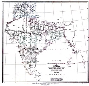
A map showing the triangles and transects used in the Great
Trigonometric Survey of India, this map produced in 1870. The Great
Trigonometrical Survey of India was started in April 1802

Location on Earth

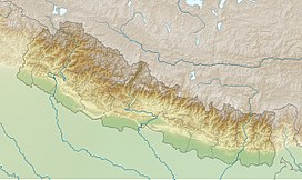
Mount Everest relief map

Morning view of Mount Everest from its southern side

From Kala Patthar
The British were forced to continue their observations from Terai, a region south of Nepal which is parallel to the Himalayas. Conditions in Terai were difficult because of torrential rains and malaria. Three survey officers died from malaria while two others had to retire because of failing health.[14]
Nonetheless, in 1847, the British continued the Great Trigonometric survey and began detailed observations of the Himalayan peaks from observation stations up to 240 km (150 mi) away. Weather restricted work to the last three months of the year. In November 1847, Andrew Waugh, the British Surveyor General of India made several observations from the Sawajpore station located in the eastern end of the Himalayas. Kangchenjunga was then considered the highest peak in the world, and with interest he noted a peak beyond it, about 230 km (140 mi) away. John Armstrong, one of Waugh's officials, also saw the peak from a location farther west and called it peak "b". Waugh would later write that the observations indicated that peak "b" was higher than Kangchenjunga, but given the great distance of the observations, closer observations were required for verification. The following year, Waugh sent a survey official back to Terai to make closer observations of peak "b", but clouds thwarted all attempts.[14]
In 1849, Waugh dispatched James Nicolson to the area, who made two observations from Jirol, 190 km (120 mi) away. Nicolson then took the largest theodolite and headed east, obtaining over 30 observations from five different locations, with the closest being 174 km (108 mi) from the peak.[14]
Nicolson retreated to Patna on the Ganges to perform the necessary calculations based on his observations. His raw data gave an average height of 9,200 m (30,200 ft) for peak "b", but this did not consider light refraction, which distorts heights. However, the number clearly indicated that peak "b" was higher than Kangchenjunga. Then, Nicolson contracted malaria and was forced to return home without finishing his calculations. Michael Hennessy, one of Waugh's assistants, had begun designating peaks based on Roman numerals, with Kangchenjunga named Peak IX, while peak "b" now became known as Peak XV.[14]
In 1852, stationed at the survey headquarters in Dehradun, Radhanath Sikdar, an Indian mathematician and surveyor from Bengal, was the first to identify Everest as the world's highest peak, using trigonometric calculations based on Nicolson's measurements.[15] An official announcement that Peak XV was the highest was delayed for several years as the calculations were repeatedly verified. Waugh began work on Nicolson's data in 1854, and along with his staff spent almost two years working on the calculations, having to deal with the problems of light refraction, barometric pressure, and temperature over the vast distances of the observations. Finally, in March 1856 he announced his findings in a letter to his deputy in Calcutta. Kangchenjunga was declared to be 8,582 m (28,156 ft), while Peak XV was given the height of 8,840 m (29,002 ft). Waugh concluded that Peak XV was "most probably the highest in the world".[14] Peak XV (measured in feet) was calculated to be exactly 8,839.2 m (29,000 ft) high, but was publicly declared to be 8,839.8 m (29,002 ft) in order to avoid the impression that an exact height of 8,839.2 metres (29,000 ft) was nothing more than a rounded estimate (in feet).[16] Waugh is therefore wittily credited with being "the first person to put two feet on top of Mount Everest".
Name
While the survey wanted to preserve local names if possible (e.g. Kangchenjunga and Dhaulagiri), Waugh argued that he could not find any commonly used local name. Waugh's search for a local name was hampered by Nepal and Tibet's exclusion of foreigners. Many local names existed, including "Deodungha" ("Holy Mountain") in Darjeeling[17] and the Tibetan "Chomolungma", which appeared on a 1733 map published in Paris by the French geographer D'Anville. In the late 19th century, many European cartographers incorrectly believed that a native name for the mountain was Gaurishankar, which is a mountain between Kathmandu and Everest.[18]Waugh argued that because there were many local names, it would be difficult to favour one name over all others, so he decided that Peak XV should be named after Welsh surveyor Sir George Everest, his predecessor as Surveyor General of India.[14][19][20] Everest himself opposed the name suggested by Waugh and told the Royal Geographical Society in 1857 that "Everest" could not be written in Hindi nor pronounced by "the native of India". Waugh's proposed name prevailed despite the objections, and in 1865, the Royal Geographical Society officially adopted Mount Everest as the name for the highest mountain in the world.[14] The modern pronunciations of Everest (/ˈɛvərᵻst/ and /ˈɛvrᵻst/)[21] are different from Sir George's pronunciation of his surname (/ˈiːvrᵻst/, EEV-rist).[22]
The Tibetan name for Mount Everest is ཇོ་མོ་གླང་མ (IPA: [t͡ɕʰòmòlɑ́ŋmɑ̀],[citation needed] lit. "Holy Mother"), whose official Tibetan pinyin form is Qomolangma. It is also popularly romanised as Chomolungma and (in Wylie) as Jo-mo-glang-ma or Jomo Langma.[27] The official Chinese transcription is 珠穆朗玛峰 (t 珠穆朗瑪峰), whose pinyin form is Zhūmùlǎngmǎ Fēng ("Chomolungma Peak").[28] It is also infrequently simply translated into Chinese as Shèngmǔ Fēng (t 聖母峰, s 圣母峰, lit. "Holy Mother Peak"). In 2002, the Chinese People's Daily newspaper published an article making a case against the use of "Mount Everest" in English, insisting that the mountain should be referred to as "Mount Qomolangma",[28] based on the official form of the local Tibetan name. The article argued that British colonialists did not "first discover" the mountain, as it had been known to the Tibetans and mapped by the Chinese as "Qomolangma" since at least 1719.[29]
In the early 1960s, the Nepalese government coined a Nepali name for Mount Everest, Sagarmāthā or Sagar-Matha[30] (सगरमाथा),[31] allegedly to supplant the Tibetan name among the locals, a usage which the Nepali government felt was "not acceptable".[citation needed]
Surveys


No comments:
Post a Comment